


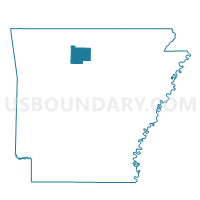
St. Joe Voting District, Searcy County, Arkansas
About
Outline

Summary
| Unique Area Identifier | 528109 |
| Name | St. Joe Voting District |
| County | Searcy County |
| State | Arkansas |
| Area (square miles) | 31.10 |
| Land Area (square miles) | 30.79 |
| Water Area (square miles) | 0.31 |
| % of Land Area | 99.01 |
| % of Water Area | 0.99 |
| Latitude of the Internal Point | 35.98686870 |
| Longtitude of the Internal Point | -92.85408920 |
Maps


Graphs
Select a template below for downloading or customizing gragh for St. Joe Voting District, Searcy County, Arkansas


Neighbors
Neighoring Voting District (by Name) Neighboring Voting District on the Map
- Calf Creek Voting District, Searcy County, AR
- Prairie Voting District, Searcy County, AR
- Springs Voting District, Searcy County, AR
- Tomahawk Voting District, Searcy County, AR
Top 10 Neighboring County Subdivision (by Population) Neighboring County Subdivision on the Map
- Spring township, Searcy County, AR (588)
- Tomahawk township, Searcy County, AR (574)
- Prairie township, Searcy County, AR (550)
- St. Joe township, Searcy County, AR (390)
- Calf Creek township, Searcy County, AR (326)